|
|
 |
 |
 |
| Northwest
Territories |
|
 Gov.
of Northwest Territories website Gov.
of Northwest Territories website  |
 |
| The
name was originally applied to the territory acquired in 1870
from the Hudson's Bay Company and Great Britain - Rupert's Land
and the North-Western Territory - which lay northwest of central
Canada. In 1880 Great Britain also transferred to Canada the
arctic islands, north of the mainland, thereby adding to the
territories. Large portions of NWT were subsequently removed
to create the provinces of Manitoba (1870), Saskatchewan (1905)
and Alberta (1905); the Yukon Territory (1898); and to add to
the areas of Manitoba (1880, 1912), Ontario (1912) and Québec
(1912). Even so, it constitutes the largest political subdivision
within Canada (34.4% of the national area) and the northernmost
landmass extending to within 720 km of the north pole. Its enormous
distances, northern location and sparse population impart distinctive
characteristics. |

|
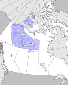
| The NWT includes a mainland
portion lying west of Hudson Bay-Foxe Basin and south of the
Beaufort Sea and other arctic marine waters to the east. North
of the mainland the arctic archipelago includes a great number
of islands of varying size and complexity. The more westerly
part of the mainland forms the Mackenzie Valley area, a subarctic
region contrasting with the arctic mainland area that lies east
and north of the treeline and is sometimes known as the Barren
Lands. This vegetation division corresponds to a cultural division
of the native peoples, with the Inuit occupying the Arctic and
the Dene, the Subarctic. The greater economic development and
larger population of the subarctic Mackenzie Valley also set
it apart from the arctic mainland. |
|
 |
|
Detailed
map ( 81 KB )

|
|