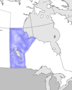
Manitoba
is the "keystone" province located in the heart of Canada. Created
by the Manitoba Act of 1870, the province was at first a tiny
rectangle comprising little more than the Red River colony radiating
from the juncture of the Red and Assiniboine rivers. After lengthy
and often difficult provincial-federal negotiations, the boundaries
were extended in 1881 and 1884. In 1912 they were finally set
at lat 49º to lat 60º N and long 101º30'-102º W to long 95º
W, angling northeast at about 53º north on the eastern boundary.
For 200 years the fur trade
dominated the area known as Rupert's Land. Settlement, particularly
from eastern Canada and eastern Europe, eventually created a
sound agricultural tradition. Postwar political and economic
efforts have enabled the economy to diversify industry and develop
primary resources, while maintaining agricultural strength.