|
|
 |
|
|
| Alberta
|
|
 Government
of Alberta Website Government
of Alberta Website |
|
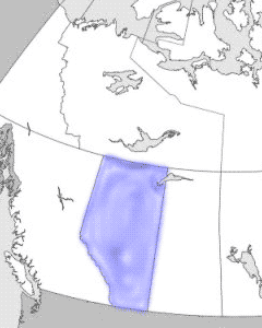
| Alberta,
the westernmost of Canada's 3 Prairie provinces, shares many
physical features with its neighbours to the east, Saskatchewan
and Manitoba. The Rocky Mountains form the southern portion
of Alberta's western boundary with British Columbia. Alberta's
western location places it at considerable distance from the
traditional economic and political power centres of Canada;
however, the province possesses the country's largest deposits
of oil and natural gas, and expansion of the petroleum industry
from 1947 to 1982 made it the fastest-growing province in that
period, producing a westward shift of economic power in Canada. |
|
|
| Though appearing quite homogeneous,
Alberta may be divided into 2 distinct sociocultural regions
- southern Alberta, with Calgary as its focal point; and central
and northern Alberta, with Edmonton as the metropolitan centre.
Politically, both regions have consistently supported conservative
parties since the 1920s, first through the Social Credit Party
and then the Conservative Party; recently opposition in the
north has tended to coalesce around the New Democratic Party
or Liberal Party provincially, while in the south it gravitates
to right-of-centre candidates. |
|
 |
|
Detailed
map (149 KB)

|
|