|
|
 |
 |
 |
| Newfoundland
|
|
 Gov.
of Newfoundland website Gov.
of Newfoundland website  |
 |
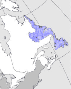
| Newfoundland,
the youngest of the Canadian provinces, joined Confederation
at midnight on 31 March 1949. Some portion of the coast of this
easternmost part of Canada was assuredly one of the first parts
of the continent seen by Europeans. Tenth-century Viking explorers
from Iceland and Greenland saw Labrador and settled briefly
in the north part of the Island of Newfoundland. In the late
15th century the Grand Banks southeast of Newfoundland were
known to Basque, French and Portuguese fishermen. |

|
| The Labrador part of the province
may have received its name from the Portuguese designation,
"Terra del Lavradors." Cape Spear, near St. John's, is the easternmost
point of the province and thus, excepting Greenland, of North
America. From Cape Spear across the Atlantic to the nearest
point in Ireland it is nearly 3000 km. Winnipeg, in mid-Canada,
and Miami in the southeast US are farther away - 3100 km and
3400 km respectively. The south coast of the province lies astride
lat 47º N lat, but Cape Chidley on the northernmost tip of Labrador
is just north of 60º N lat, giving the province a total north-south
extent of just over 1800 km. |
|
 |
|
Detailed
map (101 KB)

|
|