|
|
 |
|
|
| Nunavut
|
|
 Government
of Nunavut website Government
of Nunavut website |
|
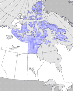
| Nunavut,
which translates from the Inuktitut dialect of the Eastern Arctic
Inuit as "Our Land," is a territorial subdivision of the erstwhile
Northwest Territories. Broadly speaking, it comprises that part
of the Canadian mainland and Arctic Islands that lie north and
northeast of the treeline as it runs from the west end of the
Dolphin Strait to some 60 km south of the point where the Tha-anne
River flows into Hudson Bay. Of the principal Arctic Islands,
it excludes Banks Island, Prince Patrick Island and parts of
Victoria and Melville Islands. The total land and offshore area
is 1.6 million km2. |
|
|
| Nunavut is subdivided into 3
designations of land: 1) Crown lands over which Inuit have the
right to hunt, trap, fish and participate in management; 2)
318 084 km2 of land that is Inuit freehold property as far as
surface rights are concerned; and 3) 37 883 km2 of land on which
subsurface rights are included with the surface freehold. Inuit
were invited to select the parcels of land for each designation.
In compensation for the Crown lands that are not to be Inuit
property, the federal government agreed to pay to recognized
Inuit organizations $1.17 billion over 15 years. Politically,
Nunavut will have its own legislative assembly, which will have
powers equivalent to those of any other federal territory, and
it will also have its own Supreme Court. |
|
 |
|
Detailed
map (118 KB)

|
|